
The phrase historic flood control systems in Asia names practices that shaped landscapes and livelihoods for centuries. These works read like field manuals for water, showing how slope, silt, and seasonality guide lasting design.
Dujiangyan on the Min River used channels and geometry instead of a dam to split flow and keep navigation open. That approach irrigated vast plains and solved sediment problems while letting transport continue.
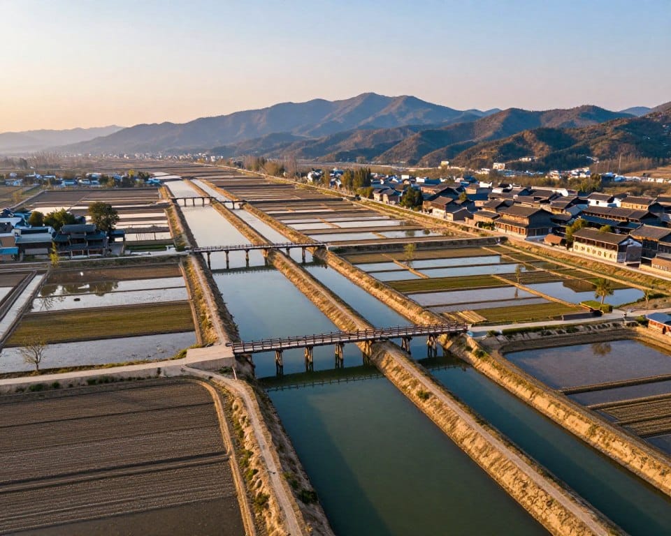
Across the region, steep rivers and monsoon climate demanded layered responses. Rice terraces store rain on slopes and slow runoff. Japanese valleys used ongoing maintenance and community governance for sediment and flow issues.
Ancient practices inform modern engineering and urban design. Green roofs and sponge-city ideas echo terrace logic by slowing runoff and cooling buildings. These lessons offer practical methods to read a basin and design resilient projects over time.
Key Takeaways
- Channel-based designs keep navigation and fields while stabilizing flow.
- Dujiangyan shows geometry can replace massive barriers for basin management.
- Steep, short rivers need continuous works and local governance for sediment control.
- Terraces act as distributed storage, smoothing peaks without hard barriers.
- Nature-based methods inspire urban tools like green roofs to reduce runoff.
- Reading slope, silt, and seasonality guides practical basin planning today.
Why Asia engineered against floods: monsoons, mountains, and fast rivers
Climate-driven downpours and energetic rivers demanded solutions that worked with flow, not against it.
Monsoon rains fall in short bursts. That concentrates water into high peaks of discharge. Steep channels then turn those peaks into rapid, erosive flows that carry heavy sediment. These pulses made flood risk acute on plains where communities rebuilt after each event.
The mountain squeeze shortens response time. Catchments routed runoff quickly. Without storage or thoughtful channel geometry, water arrives too fast for single embankments to hold.
- Engineers favored multi-path flow and safe overflow routes to spread energy and reduce damage.
- Designs sorted silt with weirs and bypass channels so navigation and supply stayed open.
- Community maintenance and seasonal operations matched the climate and saved time and labor.
Recognizing basin transitions—from confined mountain reaches to broad plains—shaped lasting works. Fast rivers taught builders to steer energy, not stop it, a principle that resurfaces in later case studies.
How to read ancient flood control: key terms, river dynamics, and design goals
A simple taxonomy makes old waterworks readable: gradient, hydrograph, and load. These three terms let readers parse field notes and plans. Short definitions help bridge past and present practice.
From steep gradients to alluvial plains: why flood control was hard in Japan
Gradient is the slope of a channel. A higher gradient raises velocity and shear on beds and banks. Japanese rivers are steep and short. That pushes erosion and moves large sediment downstream.
Hydrograph peak is the short burst of discharge after heavy rain. Baseflow is the normal low-season discharge. Return period describes how often a given peak might occur.
Silt, flow, and channel geometry: controlling water without stopping rivers
- Sediment load grows with energy and drops out on plains, raising beds and spilling water unless channels convey or relieve it.
- Design goals: split high flows safely, keep navigation, irrigate fields, and move silt without burying canals.
- Simple sections, levee set-backs, and controlled spill points modulate flow and allow inspection and repair.
Multifunctional canals combined irrigation and transport, saving land and matching hydraulic gradients. Seasonal gates, weirs, and sharing compacts were operational rules as vital as physical works. Reading a basin means tracing slopes to predict erosion, deposition, and where a tuned geometry, like Dujiangyan, can sort flow and sediments.
Dujiangyan, China: the channel-not-dam breakthrough that still works today
Where many projects built walls, Dujiangyan shaped passages to sort water and silt. Built about 256 BCE on the Min River, it redirects instead of blocks. The result is a working irrigation system that still serves the Chengdu plain.
Fish Mouth Levee and the seasonal split
The Yuzui Fish Mouth Levee cleaves the river into inner and outer streams. The inner stream supplies irrigation; the outer handles excess. Seasonal routing targets a rough 60/40 dry-season versus flood-season split to protect downstream towns while keeping supply steady.
Flying Sand Weir and Bottle-Neck Channel
The Feishayan weir uses a 200 m opening to create swirl and flush sediment back to the outer channel. Baopingkou’s throat was cut through Mount Yulei using thermal cracking. Its entrance geometry throttles flow, forms a controlled vortex, and spreads water across fields.
Materials, resilience, and modern lessons
Woven bamboo cages (Zhulong) and wooden tripods (Macha) made flexible revetments. Construction was modular and repairable. The system irrigates roughly 5,300 km2 (about 668,700 ha). It survived quakes with reparable damage.
- Open-channel engineering keeps sediment moving and avoids large dams that trap silt.
- Simple, repeatable repairs support resilience across a basin where mountains meet plains.
- Dujiangyan’s logic is transferable to other high-energy river mouths and irrigation projects.
For broader context on water and ancient innovation see waters’ role in ancient civilizations.
What Dujiangyan teaches modern engineers about flood control, irrigation, and transport
A well-placed split and a narrow throat can deliver irrigation, navigation, and safety at once.
Managing sediment with geometry, not concrete mass
Design planform and cross-section to steer sediment. Use bypass channels and a throat to create vortices that flush silt toward safe paths.
That reduces dredging and keeps canals usable for longer. It also preserves capacity across a river corridor serving farms and transport.
Keeping navigation open while protecting fields and cities
Split channels maintain a navigable thalweg while shedding peak flow to overflow routes. A narrow control stabilizes upstream levels for irrigation intakes.
- Set seasonal intake ratios to match dry and wet hydrographs.
- Favor flexible, repairable revetments made from local materials.
- Link canals to give routes for irrigation, trade, and emergency drawdown.
- Add turbidity sensors and stage recorders at split points to guide interventions.
Model intake ratios under different scenarios. That aligns ancient geometry with modern monitoring and yields reliable water supply for fields and the downstream city without overbuilding.
Historic flood control systems in Asia
A regional sweep shows how people routed, stored, and shared water over time.

The Qin era linked three great projects: Dujiangyan, Zhengguo Canal, and Lingqu Canal. Those works tied basins and made movement and irrigation reliable.
Across the region, three core types appear. Diversion levees and canals steer peak flow. Valley-head reservoirs multiply supply but require careful maintenance. Contour terraces store rain on slopes and reduce downstream peaks.
- Terraces act as distributed storage that limits runoff and bolsters food systems.
- Canals become economic arteries that link farms to markets and stabilize seasonal water.
- Reservoirs improve reliability but add breach risk that drives design and repair routines.
| Example | Primary Function | Societal Effect |
|---|---|---|
| Dujiangyan / Qin projects | Split channels for irrigation and navigation | Shaped trade routes and labor organization over a century |
| Rice terraces (China, Japan, SE Asia) | On-slope storage and runoff slowing | Increased food security across a large area |
| Valley reservoirs (Sayama, Manno) | Seasonal supply buffering | Required governance and repair regimes |
Different rivers demanded tailored solutions. Yet common success factors emerge: adaptable geometry, easy repair methods, and institutions that allocate flows by season. These features kept water moving while protecting fields and towns and set the stage for Japan’s later innovations.
Japan’s long fight with “waterfall” rivers: climate, topography, and river basins
Short, energetic channels shaped both the land and the community response across Japanese basins. High seasonal rainfall and steep profiles produce rapid hydrographs. Those pulses push overbank flows and frequent deposition on growing plains.
Alluvial plain formation and living with seasonal floods
Fast discharge built new alluvial land over years. People accepted cyclical flooding as part of landscape change. They placed houses on higher ground and kept lower plots for agriculture. As channels aggraded, risk rose where rivers shifted across a small area boundary.
Paddy farming as the driver of hydraulic innovation
Reliable water drove engineering choices. Demand for rice led villages to build embankments, weirs, and shared canals. Short response times meant early warning and tight coordination in each basin. Intake design, bank protection, and silt management improved through local practice and repeated repair.
- Steep catchments give little warning. Communities organized fast watches and labor teams.
- Paddy expansion turned depositional plains into productive but managed terrain.
- Basin thinking—headwaters to delta—guided where to slow, split, or route flows.
| Opportunity | Hazard | Planner action |
|---|---|---|
| New arable land | Channel aggradation | Seasonal operating rules |
| Concentrated population | Concentrated risk | Shared maintenance regimes |
| Rice reliability | Silt overload | Silt-smart intakes and bypasses |
From Yayoi to Ritsuryō: weirs, canals, and valley-head reservoirs
Archaeology and records show how early Japanese communities shaped land and water for rice production. Simple paddies began with narrow bunds and a shared ditch that served both irrigation and drainage.
At the Toro site archaeologists found more than 50 rectangular plots. Each plot had bunds and a central dual-purpose ditch. That layout let farmers feed crops and remove excess water fast when storms arrived.
Early paddy layouts, dual-purpose ditches, and organized labor
- Minimal earthworks evolved into ordered grids of bunds and canals that managed seasonal flow.
- Canal links from weirs gave staged delivery and rapid drawdown to protect young rice.
- Centralized surveying and labor under Ritsuryō governance enabled large-scale construction with simple tools.
Reservoirs like Sayama Ike and Manno Ike: benefits and breach risks
Valley-head reservoirs saved excavation by enclosing mouths of valleys. They stored reliable water with relatively small embankments but raised breach consequences if overtopped or shaken.
| Site | Key dates | Note |
|---|---|---|
| Sayama Ike | 616 (dendro) | Early 7th-century storage |
| Manno Ike | 821, 1184, 1854, 1959 | Repeated restorations; 15.4M m3 by 1959 |
| Nationwide | pre-Edo to Edo | ~167,000 reservoirs still present (2019) |
Warriors, manors, and water governance: who managed the rivers?
Local lords and village councils shaped who used water and when across river basins. Power moved from court stewards to manorial managers and then to warrior administrators who coordinated larger works.
Shugo, Jitō, and village compacts
Under the Kamakura shogunate, Shugo and Jitō roles solidified as estate-level authorities. They organized labor, set rights, and negotiated across estates for steady delivery.
Village compacts set intake schedules, maintenance duties, and dispute rules. The Imai system near the Katsuragawa shows how timing and rotation made irrigation equitable during variable flow.
Water wheels and pumps: moving water before fossil fuels
Water wheels and treadmills lifted water where gravity failed. More than 100 wheels were recorded near Ujigawa and Ogura Ike. Asakura’s multiple-wheel setup dates to 1789 and follows a five-year renovation cycle maintained by local artisans.
Simple technology ran on river energy and human upkeep. Dr. Tetsu Nakamura later adapted this approach to irrigate 40 ha in Afghanistan, moving about 1,200 tons of water per day.
| Role | Function | Example |
|---|---|---|
| Shugo / Jitō | Basin coordination, labor mobilization | Kamakura period, 13th century |
| Village compact | Intake schedules, repairs, arbitration | Imai near Katsuragawa |
| Artisans | Maintain wheels and weirs | Asakura wheels; five-year renewals |
- Population clusters relied on predictable delivery, driving investment in canals, embankments, and weirs.
- Institutions and technology co-evolved; formal roles enabled estate-scale works and routine inspection over time.
- Strong governance lowered conflict and improved adaptation during droughts and high flows.
Rice terraces as living flood control: contouring slopes to store and slow water
Terraced fields turn steep slopes into a network of small, level basins that store rain and tame runoff.
Hani terraces and river overlooks: filtering mountain runoff
Hani terraces in southern China sit above valley rivers. They intercept fast runoff from the mountain slope. Sediment drops in ponded plots. Cleaner, slower water then reaches the river below.
Contour logic: equal elevation layers that spread and absorb flow
Terraces follow contour lines so each layer holds water at the same elevation. That spreads inflow across a wide bench and reduces erosive energy.
Ponded layers protect soil and increase infiltration. Steep land becomes productive rice paddies that store moisture for planting.
- Terrace chains act as distributed retention basins that blunt peak flow during storms.
- Farmers gain longer soil moisture, less topsoil loss, and steadier planting windows.
- Well-designed spill points prevent cascades and link terraces into a resilient system.
- Benefits for the environment include lower turbidity and improved downstream habitat.
Sponge city roots in rural wisdom: from terraces to today’s urban design
Old on-slope storage methods offer a clear blueprint for modern urban water design. Yu Kongjian framed the sponge city idea from terrace practice. Terraces hold rain on slopes and release it slowly. That lowers peak flows before runoff reaches rivers or drains.
Distributed storage beats single hard barriers for short, intense storms. Small basins, bioswales, and permeable streets act like terrace steps across blocks. They reduce peak discharge and ease stress on pipes.
- Surface and shallow subsurface routing keeps flows manageable and visible.
- Monitoring technology tracks storage levels and outflow to optimize performance during multi-day events.
- Retrofits should target high-runoff areas first to maximize benefits quickly.
- Co-benefits include better water quality, urban irrigation for rooftop gardens, and cooler land surfaces.
| Feature | Terraces | Urban sponge |
|---|---|---|
| Storage type | Shallow, distributed | Shallow, distributed |
| Maintenance | Visible, community-led | Simple, monitorable |
| Primary benefit | Silt capture and irrigation | Reduced peak runoff and cooling |
Planners should pair these nature-based measures with early warning tools. Simple, maintainable features invite community stewardship and long-term resilience.
Green roofs and urban flood mitigation: lessons from Bangkok’s runoff problem
Green roofs slow runoff and cool buildings. Bangkok shows the scale of benefit. Vegetated decks can slow runoff by about 20 times versus bare concrete. They also cut indoor temperatures by 2–4°C in hot seasons.
Storage media, growing layers, and drainage mats control release rates. That protects downstream inlets during peak storms. Roof substrates hold water and filter particulates and nutrients before slow discharge.
Performance and practical steps for US cities
- Metric: ~20x slower runoff reduces peak load on storm pipes.
- Thermal: 2–4°C cooling lowers cooling demand in hot, humid areas.
- Target large flat roofs in dense districts with high impervious cover.
- Pair with sensors to track saturation and time releases ahead of storms.
- Keep seasonal maintenance: clear drains, check vegetation, replace media when needed.
- Integrate with irrigation reuse to reduce potable water use for landscaping.
| Metric | Bangkok Data | US Application |
|---|---|---|
| Runoff slowdown | ~20x slower vs concrete | Relieves peak loads on combined sewers |
| Indoor cooling | 2–4°C reduction | Lower AC energy and peak demand |
| Water quality | Captures particulates, nutrients | Reduces upstream pollutant loads |
| Operational need | Seasonal checks and drain clearing | City maintenance programs and building owners |
Green roofs work best as part of a sponge toolbox. Combine them with streetside bioretention and detention parks. Use simple sensors and forecasts to time releases. This pairing reduces urban runoff risk while improving comfort and the urban environment.
Materials and methods that mattered: bamboo cages, stone, wood, and earthworks
Builders chose flexible, local materials that let river works bend and heal over time.
Woven bamboo cages filled with stone (Zhulong) acted as permeable armoring. They absorb energy and settle with shifting beds. Fine soil and sand can pass through while larger stones protect the core.
Wooden tripod frames (Macha) served as rapid, modular supports. Crews used them for staged diversion and emergency fixes. They speeded construction and simplified replacement after high flow events.
Thermal cracking used heat and cold water to fracture rock where blasting was unavailable. It sped channel cutting and made spillways possible with simple tools and labor over time.
- Embankments relied on compacted lifts of soil with stone facing for scour resistance.
- Wooden sluices provided adjustable water release and easy repair.
- Permeable armoring reduced pressure buildup compared with mass concrete that traps sediment and demands dredging.
| Material | Function | Maintenance |
|---|---|---|
| Bamboo + stone | Flexible armoring, energy dissipation | Replaceable, local |
| Wood tripods | Temporary diversion, staged works | Rapid repair |
| Stone facing | Scour resistance | Periodic resetting |
Material choices shaped inspection routines. Visible wear signaled timely intervention. Modern gabions and articulating blocks mirror ancient solutions and linked old engineering to present technology.
Designing for failure and repair: breaches, earthquakes, and continuous maintenance
Resilience begins by planning safe escape routes for excess water and clear steps for quick repair.
Manno Ike shows long time trade-offs. Rehabilitated by Kūkai in 821, it later breached in 1184 and again after the 1854 quake. Engineers raised embankments in stages and upgraded spillways to reduce repeat loss. By 1959 capacity reached 15.4 million m3 after successive works.
Dujiangyan illustrates another path. Its open-channel design limited impoundment level and kept diversion running even when the Yuzui levee cracked after the 2008 quake. That geometry let crews repair parts without stopping irrigation or navigation.
Practical takeaways for risk management
- Assume overtopping, settlement, and seismic shock. Plan safe failure paths.
- Target inspections on crest settlement, seepage, and spillway integrity.
- Favor modular, local-material components for fast reconstruction.
| Inspection target | Frequency | Response |
|---|---|---|
| Crest settlement | Seasonal | Regrade and compaction |
| Seepage/piping | Monthly in wet season | Filter collars, trench relief |
| Spillway gates | After high flows | Clear, repair pintles |
Embed monitoring for level, pore pressure, and deformation. Fund maintenance cycles and preassign crews before high flows. Preserve original hydraulic logic while adding reinforcement where it reduces risk. Plan scenarios for extreme floods and earthquakes in mountain-front basins to keep banks, fields, and towns safer.
From canals to commerce: how water control shaped cities, fields, and society
Lake Biwa and the Yodo river network sustained Kyoto’s trade and food supply for more than a millennium. Lake regulation smoothed seasonal peaks and kept navigation viable toward the city over long time horizons.
Lake Biwa, the Yodo system, and transport into Kyoto
Transport on Lake Biwa linked Kyoto to the Sea of Japan and eastern ports. Boats carried grain, timber, and construction materials that fed markets and building programs.
The Kamogawa behaved more erratically. It overflowed banks repeatedly, which highlighted the value of upstream regulation and stable routes for commerce.
- The Tōgō/Juugo canal built in 1110 irrigated 600 ha for Kōfukuji and doubled as a transport canal.
- Canal links and regulated river reaches secured grain flows and raw materials into warehouse districts.
- Reliable routes concentrated population near landings and spurred guilds, maintenance crews, and river-right institutions.
| Infrastructure | Primary role | Effect on area |
|---|---|---|
| Canal (Tōgō/Juugo) | Irrigate 600 ha, carry goods | Tightened city-field ties |
| Lake Biwa regulation | Stabilize flow, maintain navigation | Long-term trade reliability |
| Kamogawa | Local drainage, volatile flow | Frequent overbank repair |
Centuries of coordinated management secured rice surpluses and urban demand. That investment underpinned economic resilience and cultural growth along riverfronts. Modern freight waterways can mirror these gains when paired with safety and habitat restoration.
Applying ancient principles to today’s climate risks and monitoring tech
Combining ancient channel design with sensors creates a practical roadmap for resilient water and river works. Dujiangyan’s geometry shows how a split and a throat sort silt naturally. That reduces dredging and preserves conveyance under climate extremes.

Sediment-smart channels, controlled connectivity, and basin-scale thinking
Design channels to sort sediment and keep a navigable path. Add bypasses and spill corridors that activate on high flows. Coordinate upstream and downstream actions so one project does not move risk to another community.
Sensors and remote monitoring layered onto timeless hydraulics
- Install stage, turbidity, and flow sensors at splits and intakes to automate decisions.
- Use remote stations and autonomous platforms to gather continuous data in hard reaches.
- Tie sensor feeds to rules that shift intake ratios seasonally and to forecast-informed operations.
- Prioritize modular, repairable works so crews restore function fast after shocks.
| Measure | Action | Benefit |
|---|---|---|
| Sediment-smart geometry | Throats, bypass channels | Less dredging, stable conveyance |
| Monitoring | Stage & turbidity sensors | Automated operations, timely alerts |
| Remote platforms | Autonomous gauges and samplers | Continuous data in remote reaches |
| Modular works | Local materials, replaceable units | Faster repairs, lower lifecycle cost |
How to evaluate a river basin the ancient way—then add modern tools
Ancient engineers read rivers like layered maps. They noted where steep slope ends and plains begin. Those transition points guide safe diversion and irrigation choices today.
Read the slope, silt, seasonality; model flows with today’s data
Start by mapping gradient breaks and deposition zones. Watch where sediment drops as a clue to intake placement. Record seasonal water patterns to set intake ratios.
- Start upstream: map breaks where mountain energy eases and mark natural diversion points (river basin).
- Track sediment: find deposition zones and plan channels that pass silt without burying fields.
- Read seasonality: define wet and dry cycles and set target intake ratios and spill thresholds.
- Mark flood corridors: reserve land for overbank flow and controlled bypasses.
- Size channels and weirs with current hydrologic data while honoring open-flow redundancy.
- Add sensors for level and turbidity at control points to verify performance in near real time (technology).
- Favor simple, repairable materials and integrate canals as service routes and emergency outlets.
- Budget operations and validate with small pilots before scaling.
| Ancient observation | Modern tool | Benefit |
|---|---|---|
| Gradient breaks | Topographic maps & GIS | Pinpoint diversion sites |
| Sediment behavior | Turbidity sensors | Protect intakes and fields |
| Seasonal rhythm | Hydrologic modeling | Set intake ratios and spill rules |
For historical context and broader methods see waters’ role in ancient civilizations.
Conclusion
Durable water projects show how geometry, shared rules, and repairable materials keep a river working for people and crops. They balance supply and safety while supporting irrigation and transport.
Designers should favor channel geometry, distributed storage, and controlled connectivity to manage peak flows without shutting waterways. Operational rules and local governance matter as much as physical works.
Apply terrace logic and sponge-city ideas to urban planning. Pair ancient tactics with sensors and monitoring to run sediment-smart channels and green roofs that cut peak runoff and improve water quality.
Start with basin-scale pilots, fund routine maintenance, and build modular, repairable works. These steps help translate lessons learned over years into practical solutions for today.